
Any survivor that wishes to successfully navigate the terrain must have a sense of direction and a known current location. Without both of these, you will likely wander aimlessly to your ultimate death. Many of us have become accustomed to devices that handle this for us such as Global Positioning System (GPS) and the idea of using maps and directions are a foreign concept.
There are many real world methods of finding north that can be used in DayZ such as the “shadow stick method”, however this guide will only touch on the fastest methods. Due to the immediate need for warmth, food, and water, many of the real world methods for finding north take too long to be suitable for surviving in DayZ.
There are many details about accurate direction finding that will be excluded from this document for simplicity’s sake such as “magnetic north” vs “true north”.
The simplest way to remember the orientation of the cardinal directions is to remember the word “NEWS”. (N)orth is at the top, followed by (E)ast immediately to the right. West and south are simply the opposite of east and north.
The intermediate points between the four primary cardinal directions are: northeast (NE), southeast (SE), southwest (SW), and northwest (NW).
The intermediate points between the eight cardinal directions listed above are generally used for more accurately relaying the location of something in the distance. They are: north of northeast (NNE), east of northeast (ENE), east of southeast (ESE), south of southeast (SSE), south of southwest (SSW), west of southwest (WSW), west of northwest (WNW), and north of northwest (NNW).
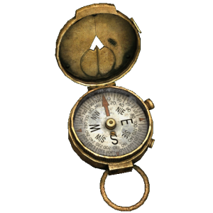
Use a compass. The compass point that is highlighted differently than the other directions is usually north.
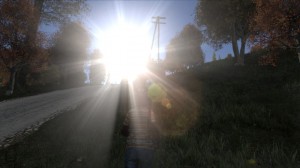
Find the sun. Chernarus is located in the northern hemisphere which puts the sun generally in the southern part of the sky. Also if you remembered the time of day before you joined, you can find East/West by the sun’s location to the horizon. “The Sun: Rises in the east, Sets in the west”.
If you are grouped with someone that has a compass, ask them for the direction of the sun. If you are not in a group or it is cloudy, you will have to rely on alternate methods.
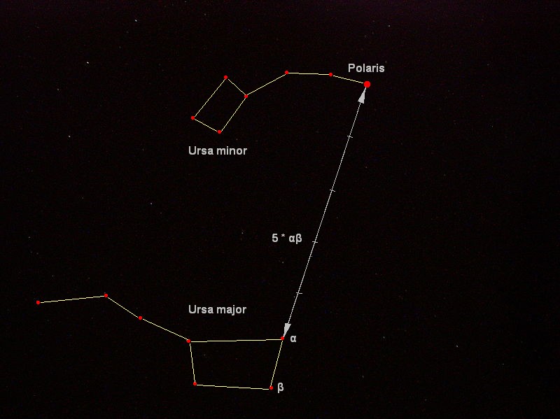
Find Polaris, the North Star. Look for the constellation Ursa major (“The Big Dipper”) in the sky. Follow the two stars in the “scoop” part of the dipper, from the bottom to the top of the dipper, until you reach the brightest star in the sky. This star will be the North Star, Polaris, and should reside in a constellation called Ursa minor (“The Little Dipper”).

Elektrozavodsk map from iZurvive.com
External map resources: HERO DayZ Overlay (powered by iZurvive), iZurvive, DayZDB
Whatever map you choose for navigation, spend time learning how to read the map and identify landmarks. The above map sample from iZurvive contains lots of information including: topographical markings, railroads, primary roads, secondary roads, trees, buildings, water, and power lines.
North is usually located at the top of the map.
These are usually brown lines without any endpoints. These lines show changes in elevation with each line representing a certain amount of elevation change. Topographical lines close together show a steep gradient, lines farther apart show a long sloping gradient. In the top right of the map sample above, you can see a forested hill overlooking Elektro often referred to as “Sniper Hill”.
Run in any direction. This is probably the worst method for finding direction, but sometimes you have to know where you are before you can go where you want. Look for landmarks (the coast, roads, train tracks, power lines, cities, rock formations, hills and mountains) that can be coupled with a map to try and guess your position.
If you come to the coast, you can make the assumption that you are on the eastern or southern part of the map. You may need to run along the coast until you come across a town to identify exactly where you are.
If you come across a town, try and find the welcome sign that shows the name of the town. Use unique features in the layout of the town to figure out which town it is. Examples of unique features include railroads, forks in the road or unique shapes and bends in the road, large or small town size, etc. Study a map and try to eliminate towns that definitely are not the town you are in. You will likely have a few candidates left that you can verify as you move around in the town and locate other unique features. Once you know the town you are in, you can find north by using a map to locate the northern part of the town and then try and find that direction as you move around.
After you have established north with this worst case scenario, you will need to work hard to keep orientation. If the sun is out, you can use that as a stationary object that you can reference later as you travel between destinations. It may be best to stick to following roads until you are more experienced at maintaining orientation without a compass.